
Hello! So if you have read my previous post, at the end I detailed the effort that it actually took to make it to Santorini, Greece. Quite the effort...I know. However, this was the view that we woke up to in the morning on the ferry after sleeping on a row of seats. It was wonderfully warm air with a ship that sailed under the Greek flag, and Greece in the distance.
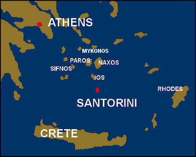 For those of you who, like me, are a bit lacking in knowledge of Greek geography, here is a quick lesson of where we traveled.
Once on the island of Santorini (whose proper name is actually Thira but the Italian name just stuck I guess) we stayed in the main town on the island called Fira.

"The present-day crescent shape of the island is a consequence of the activity of the volcano in prehistoric times feeding the myth of the lost Atlantis. Santorini is essentially what remains of an enormous volcanic explosion dated back 3,600 years and which created the current geological caldera; a giant central lagoon, more or less rectangular, and measuring about 12 by 7 km (7.5 by 4.3 mi), surrounded by 300 m (980 ft) high steep cliffs on three sides.
The mild activity of the volcano after this major eruption has built up two small islands within the caldera, Palea and Nea Kameni, visited by hundreds of people everyday during the tourist season.
The impressive caldera dominates the west part of the island, while the marvellous dry climate and the almost continuous sunshine create year-around conditions which are perfect for observation, photographs and videos under an extraordinary variety of natural lights and colours that give the visitor the exceptional advantage of reaching the interior of the volcano by boat" (http://www.santorini.net/camera/caldera.htm).

So here is the town of Fira on Santorini. This island was made famous by the blue domed roofed houses that are built into the cliffs here on the island most notoriously in the village of Oia (ee-uh).

One day we explored the village of Oia then did an amazing 3 hour hike back to Fira along the cliffs facing the Caldera (volcano).


Gotta love the dramatic feel of this photo in this empty church courtyard. Actually because it was in November much of the island was quite empty since most of it's sustaining economic income is tourism here.

Making our hike back to Fira. The village in the background is Oia.

You can barely make out Fira in the distance. It is not the first grouping of buildings you see but the next one waaaaayyy back there. You can also see the ferry heading out from the port and it just made it past the volcano.

This area is known for it's amazing sunsets, and now I understand why. We saw some mesmerizing views such as the one pictured above.

We also went swimming (and yes we were the only ones). Here at this beach the island was even more like a ghost town but when a local on occasion did drive by, they did not try to hide their shock and commence to stare at us until we were out of view.
Here is a short video from Perissa beach. The photo below is us trying to take a duo photo. Of course I nearly fall as the photo is about to be taken, thankfully Lexi grabs my arm to steady me. What a champ!


Another day we went on an excursion to explore the volcano. The shots above and below are views from this hike.
Below is the view of Fira from the volcano.


After our excursion we take a donkey ride up the staircase. The owner of these donkeys placed Lexi on one of the first donkey, once she was on he turned the donkey around gave it a slap on the butt and the donkey literally began to run up the stairs. The hilarious part is that you have no reins, so the donkey just kinda goes where it wants at the pace it wants. Here is a description someone wrote about this experience:
"I got given some great advice before I hopped on my donkey- you aren't riding the donkey- the donkey is taking you for a ride. You have no reins to guide the donkeys, and the donkeys do what they want to- whether it be barrelling straight towards tourists walking down, or stopping to lick the wall or check out the view. Basically they go at their own pace, and decide which donkeys they want to keep up with. Hold on and enjoy the ride and views."


Here is a bot of information on this place :
The excavations at Akrotiri have uncovered one of the most important prehistoric settlements of the Aegean. The first habitation at the site dates from the Late Neolithic times (at least the 4th millennium BC).
During the Early Bronze Age (3rd millennium BC), a sizeable settlement was founded and in the Middle and early Late Bronze Age (ca. 20th-17th centuries BC) it was extended and gradually developed into one of the main urban centers and ports of the Aegean.
The large extent of the settlement (ca. 20 hectares), the elaborate drainage system, the sophisticated multi-storeyed buildings with the magnificent wall-paintings, furniture and vessels, show its great development and prosperity.
The various imported objects found in the buildings indicate the wide network of its external relations. Akrotiri was in contact with Crete but also communicated with the Greek Mainland, the Dodecanese, Cyprus, Syria and Egypt.
The town's life came to an abrupt end in the last quarter of the 17th century BC when the inhabitants were obliged to abandon it as a result of severe earthquakes. The eruption followed. The volcanic materials covered the entire island and the town itself. These materials, however, have protected up to date the buildings and their contents, similar to Pompeii (http://www.santorini.com/archaeology/akrotiri.htm).


The lighthouse at the southern tip of the island.

I hope these people didn't mind us standing on their roof...but we did get a cool shot :)
After our ten day stay in Santorini we headed back to Athens in order to catch a flight to Germany...next post coming soon
Thanks for reading!
Thanks for your grateful informations, am working in Tourism Portal, so it will be helpful info for my works.
ReplyDelete